

The BEST building on Midlothian Turnpike (1971)
Mar 30, 2024
2
There is a large rectangular brick building at Agency Avenue and Midlothian Turnpike that was art for almost 2 decades. BEST Products was founded in…
History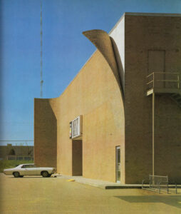
The BEST building on Midlothian Turnpike (1971)
Mar 30, 2024
2
There is a large rectangular brick building at Agency Avenue and Midlothian Turnpike that was art for almost 2 decades. BEST Products was founded in… 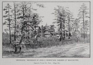
Brookside (circa 1893)
Mar 25, 2024
After John Cullen Robertson (one of the original owner-developers of the Forest Hill streetcar line) died in 1922, his widow, deGraffenried “Graffie” Taylor Robertson, demolished… 
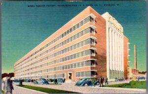
Model Tobacco (undated)
Mar 15, 2024
“Model Tobacco Factory, Petersburg Pike (U.S. Route No. 1), Richmond, Va.” via James Branch Cabell Library – Special Collections and Archives . Reverse of the… 
Stratford Hills (1954)
Mar 9, 2024
1
This great video from VDOT has an early pic of Stratford Hills: In November 1954, new signs and pavement markings had just been installed to… 
Four historic post cards from Forest Hill Park
Mar 6, 2024
Four historic postcards from VCU Libraries’ “Rarely Seen Richmond”. Source link for top image. H/T The Shockoe Examiner 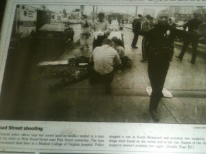
Richmond’s worst year?
Mar 4, 2024
1
Richmond bottomed out in 1994: one city council representative went off to rehab for his heroin problem and another was in hot water for not… 
214 Cowardin Ave (1955)
Mar 3, 2024
Advertisement in the Summer 1955 issue of University of Richmond Magazine Now the home of United Nations Church. 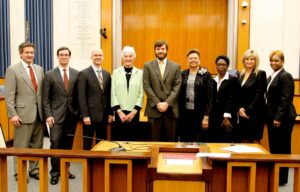
FUN FACT: Two of our current City Council representatives are THE longest serving in the modern history of city government
Feb 29, 2024
1
In 1977, Richmond elected it’s first City Council under the current nine district set up. The big deal in 1977 was whether or not it… 
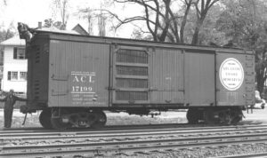
Do you know about the South Richmond mummy?
Feb 25, 2024
It’s simple story of a man found dead in a box car in 1922, who was embalmed, became a mummy, and was kept low-key on… 
That time a city councilman faked his own death
Feb 19, 2024
Raymond D. Royall, Southside resident and owner of a Highland Springs auto dealership, ran for City Council in 1970 and came in 21st place. This… 
Forest Hill and Cherokee (1978)
Feb 13, 2024
3
via James Branch Cabell Library Special Collections and Archives The city has a photo from 2018 of that since-demolished house at 2916 Cherokee right there… 
Scroll though time with the Sanborn Fire Insurance Maps
Feb 12, 2024
3
With all the help by Riley Champine The Sanborn Fire Insurance maps are a set of incredibly detailed maps of cities across North America published… 
City of Richmond Virginia and environs (1925)
Feb 4, 2024
2
As I’ve begun looking at the area through a more specific lens, I keep getting echoes of the 1914, 1942, and 1970 annexations that grew… 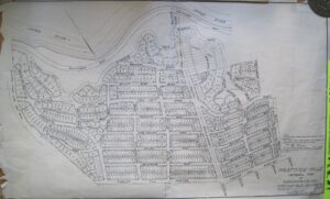
1928 plat map of Westover Hills
Feb 1, 2024
A map of the original plans for the Westover Hills neighborhood (via the Westover Hills Facebook). The WHNA sold copies of the map for while… 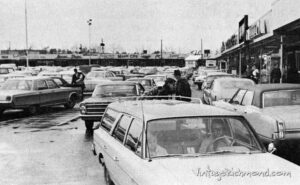
Southside Plaza (1960s)
Jan 27, 2024
From the late great Vintage Richmond blog: Here’s a picture of a booming Southside Plaza in the late 1960s. Southside Plaza originally opened in 1957,… 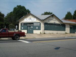
The Appliance King (undated)
Jan 15, 2024
1
Undated photo of 3416 Semmes Avenue, currently Coqui Cyclery. [via] 

© 2024 South Richmond News LLC | All Rights Reserved
© 2024 South Richmond News |
ART & MUSIC
RECENT COMMENTS
Kendy Lewis on The new Southside Community Center is a jewel of Richmond J Gregorian on Southside People’s Assembly coming to Hull Street Library Shamora Jones on City Council to consider support for affordable housing on Snead, senior housing on Semmes chairmanbrando on Richmond Police have adopted a new non-lethal device “for brief control of non-compliant individuals without use of force” Bobby H. Tyler on Victim identified, arrest made in January shooting on Greshamwood Place
THIS WEEK'S CALENDAR
|